Overview
Bolin Creek traverses two very different bodies of rock: the Carolina terrane (formally known as the Carolina slate belt) and the Durham Triassic basin.
From its headwaters near Bald Mountain to East Franklin Street, Bolin Creek flows over the slightly-metamorphosed igneous rocks of the Carolina terrane. Rocks in this portion of the Carolina terrane are approximately 630 to 615 million years old and are very resistant to erosion. As Bolin Creek flows east from East Franklin Street and past the University Mall area, it traverses two younger rock types in the Durham Triassic basin: 1) approximately 225 million-year-old sedimentary rocks; and 2) approximately 200 million-year-old igneous rocks called diabase. The sedimentary rocks are more easily eroded than the resistant diabase that intruded the Triassic basin.
The rocks exposed along Bolin Creek and Chapel Hill area record a long and sometimes violent geologic past of more than half a billon years of Earth’s history. To “Dig Deeper” into the geology of the area, read on and explore the links at the top of the page.
This website describes the geology of Bolin Creek from its headwaters near Bald Mountain to its intersection with Booker Creek as it flows into Little Creek. It not only tells the geologic story of the Creek but also of the entire Chapel Hill and Hillsborough, North Carolina area. The majority of the information presented is adapted from A Geologic Adventure Along the Eno River (Bradley, 2007) published by the North Carolina Geological Survey.
This website is separated into several parts:
- General background of the Bolin Creek area with respect to the geographic and geologic setting (below).
- The Rocks of Bolin Creek
- The Geologic History of the Chapel Hill – Hillsborough Area
- Photographs of Representative Rock Types
- References
The headwaters of Bolin Creek begin on the southeast side of Bald Mountain (Figures 1 and 2) a few miles northwest of Chapel Hill and Carrboro, North Carolina. Just east of Bald Mountain the two named tributaries of Bolin Creek (Buckhorn Branch and Jones Creek) join to form the main course of the creek. From its headwaters, Bolin Creek flows approximately 9 miles through the northern portions of Carrboro and Chapel Hill before flowing past the University Mall area (Figure 3) were Booker Creek and Bolin Creek join to form Little Creek. This relatively short journey of Bolin Creek flows past a contrasting landscape of steep river banks, forests, beaver swamps and urban areas yet the rocks exposed along the creek record a long and sometimes violent geologic past of more than half a billon years of Earth’s history.
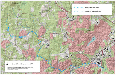
Figure 1: Topographic map of Bolin Creek from its headwaters southeast of Bald Mountain to where it joins Booker Creek to form Little Creek near the University Mall Area.
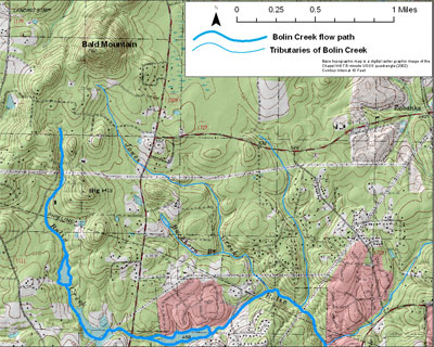
Figure 2: Topographic map of Bolin Creek in the area southeast of Bald Mountain.
Geographic Setting of Bolin Creek
A significant topographic break occurs along Bolin Creek just west of the University Mall area (Figure 3). At this location, Bolin Creek flows from a portion of the Piedmont sometimes referred to as the Piedmont upland into another portion of the Piedmont known as the Triassic lowland. This topographic break is caused by two fundamentally different rock types. The Piedmont upland is underlain by very hard and resistant metamorphosed igneous rocks and the Triassic lowland are underlain by relatively soft and less resistant sedimentary rocks of the Durham Triassic basin (Figure 4).
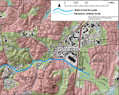
Figure 3: Topographic map of Bolin Creek in the University Mall area.
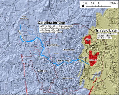
Figure 4: Map showing the location of Bolin Creek with respect to the Piedmont upland and Triassic lowland and corresponding rock types.
The top of Bald Mountain in the Piedmont upland (just northwest of the headwaters of Bolin Creek) has an elevation of approximately 762 feet above mean sea level (msl). Near the headwaters of Bolin Creek the elevation of the ground is approximately 600 to 590 feet above msl. The elevation of the Bolin Creek in the University Mall area is approximately 250 feet above msl. A 3-D generalized diagram of Bolin Creek is provided as Figure 5 to illustrate the change in topography from the Piedmont upland to the Triassic lowland.
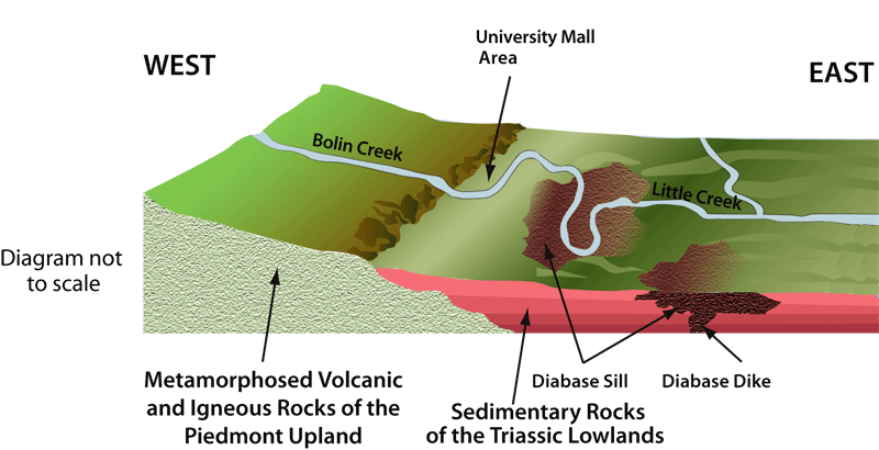
Figure 5: – 3-D generalized diagram of Bolin Creek as it flows over the boundary of the Piedmont upland and Triassic lowland.
The difference in elevation and rock type between the Piedmont upland and the Triassic lowland affects the speed at which the water flows and the shape of the river’s floodplain. In the Piedmont upland, Bolin Creek is characterized by fast moving water, where erosion has deeply cut the rock into a relatively narrow, V-shaped river valley. Floodplain deposits are typically restricted to thin strips (10 to 100 feet / 3 to 30 meters wide) on the banks of the river. Locally, slightly larger floodplain deposits may be present upstream of very resistant layers of rock. These resistant layers form a local base level that temporarily slows the river, allowing sediment to be deposited, and prevents the river upstream of the base level from eroding and deepening its valley.
Where Bolin Creek flows into the sedimentary rocks in the Triassic lowland, the creek flows through a much broader valley. The creek is not cutting down as much as it was in the Piedmont upland, and the sedimentary rocks over which it is flowing are soft and easily eroded. The creek is able to flow across a much wider valley and develop a wide floodplain.
The difference in character between Bolin Creek in the Piedmont upland and Bolin Creek in the Triassic lowand is reflected in the gradient of the river. The gradient is a measure of the change in elevation of the river as it flows. The higher the gradient of a river or stream, the faster the velocity of the water and the more erosive the flow. In the Piedmont upland, from the Bald Mountain area to East Franklin Street, Bolin Creek has an approximate gradient of 40 feet for each mile of flow. In the Triassic lowland, between East Franklin Street to where Little Creek starts being impounded by Jordan Lake, the approximate gradient of the river is 5 feet per mile. This drastic change in gradient and resulting slowing of the water in Bolin Creek, may be one of the reasons the University Mall area floods during periods of high rainfall. All of the water coming off the Piedmont upland slows down after entering the Triassic lowlands and “piles up” at times causing flooding.
About Bolin Creek Geology Website and Contact Information:
This website was prepared by Phil Bradley in an effort to help facilitate earth science education in the Chapel Hill – Hillsborough, NC area. The website conveys general geologic principles with examples from the “backyard” of the residents of Chapel Hill, Carborro, Hillsborough and Durham, NC area . Comments or identification of errors or technical inaccuracies can be directed to Phil Bradley: pbradley1968@gmail.com
My granddaughter wants to go dig in the area. She talks about it a lot. How do we do it and exactly where? Who do we call to find out how to take her there? Please help us. June McNamara 919-971-6001