Resources
for bolin creek
Resources
Links
- Adams Tract Trail Map
- All About Birds
- Clean Jordan Lake
- Clean Up the Coal Ash Dump in Chapel Hill
- Conservancy Buys 615 Acre Brumley Forest
- Conservation Guide to Bolin Creek Natural Area
- Conservation Map
- Demonstration Rain Garden Is Now Installed
- Haw River Assembly
- Lands Legacy Program
- New Hope Audubon
- North Carolina Wildlife Federation
- Orange County Parks & Facilities
- The Future of Upper Bolin Creek, 2004
- The Best Choice for Bolin Creek
- Triangle Land Conservancy
- Upper Bolin Creek Bikeway Connections
with Riparian Stream Buffer Map - USGS Stream Gauge on Bolin Creek
- Water: Earth’s Essential Thread
Report Creek Pollution
Town of Carrboro
-
Debbie Shoffner, Town of Carrboro
- Randy Dodd, Town of Carrboro
Orange County
- Patrick Mallett, Erosion Control & Stormwater and Engineering Supervisor / 919-245-2577
- Christopher Sandt, P.E. Staff Engineer / 919-245-2583
- Steve Kaltenbach, Erosion Control Officer II / 919-245-2588
- Kenneth Owens, Erosion Control Officer II / 919-245-2584
- Nathan Jacobsen, Erosion Control Officer I / 919-245-2580
Town of Chapel Hill
Report water pollution, drainage, and storm drain problems by calling 919-969-7246 (RAIN)
- Sammy Bauer, Town of Chapel Hill
- Sue Burke, Town of Chapel Hill
NC Department of Environmental Quality
- Ivanna Barham
- Lauren Garcia
Orange County Trails
Want to get outside and see the creek? Check out the Adams Tract off of Wilson Park in Carrboro. These woodland walking paths will lead you across the hillside and down to Bolin Creek. In this unpaved section of the forest, you can find early spring wildflowers and water critters in the creek, and numerous birds and other forest wildlife.
Also, check out the paved Bolin Creek Trail in Chapel Hill that connects the Community Center Park and Umstead Park. Parking is available at both ends. For the unpaved experience in Chapel Hill, park at the Community Center and follow the signs to Battle Park woodland trail that commects to the University of North Carolina’s outdoor Forest Theater.
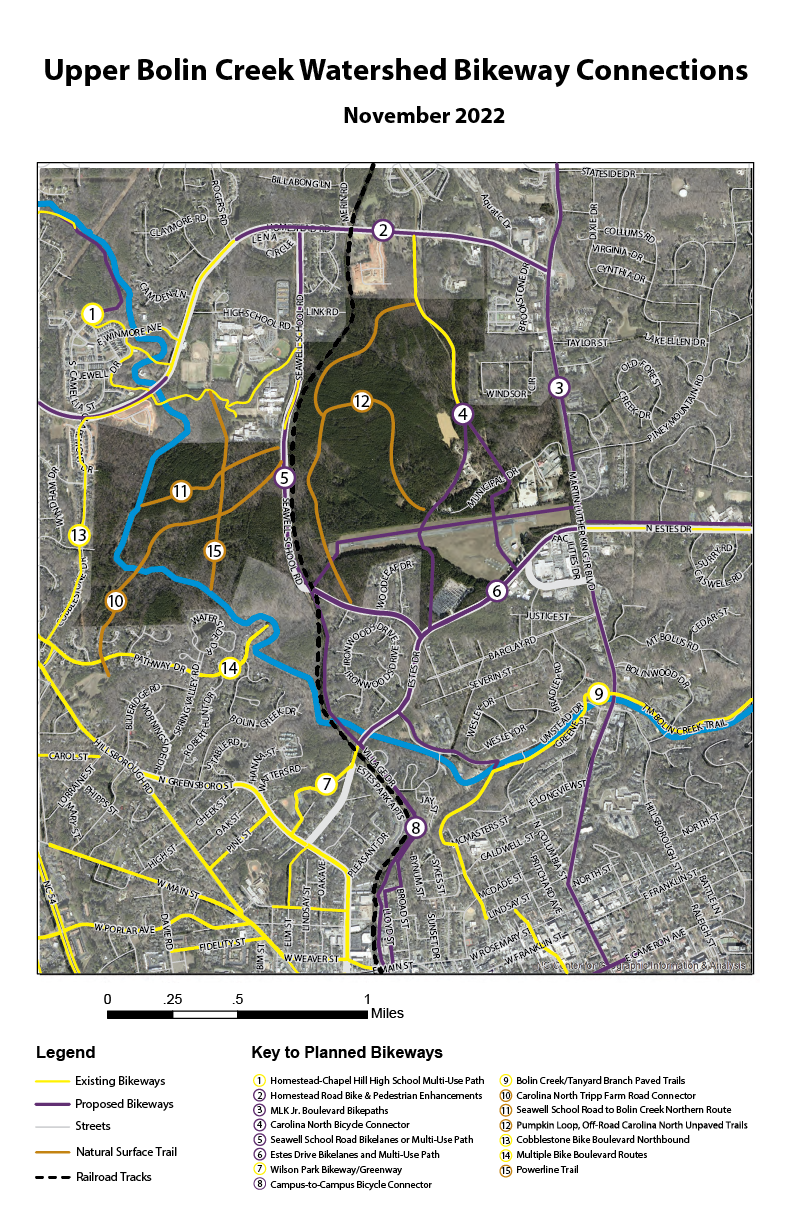
Interested in biking? Check out these bicycle routes near Carolina North and Upper Bolin Creek!
Also check out the map from Trailheads, of good running trails along the creek.

Local Watershed Ordinances
Chapel Hill property owners with land adjacent to streams may now have new restrictions for maintenance or development in addition to those under Chapel Hill’s Resource Conservation District, Watershed Water Supply District, and National Flood Insurance Program. In the interest of cleaning up Jordan Lake, an increasingly polluted drinking water supply reservoir, recreation area and wildlife habitat, the State requires all local governments within the Jordan Lake Watershed to adopt ordinances, policies and procedures based on a State model to protect and preserve existing stream buffers.
Chapel Hill’s Jordan Watershed Riparian Buffer Protection Ordinance is scheduled to become effective immediately upon adoption on Monday, December 6th as Section 5.18 in Chapel Hill’s Land Use Management Ordinance. As part of an overall nutrient reduction strategy for the lake, these new stream buffer requirements will affect maintenance and development within the 50-foot buffer along streams subject to the Jordan Lake Rules. The Jordan Lake buffer rules apply only to streams that are shown on either the USDA County Soil Survey Maps or the US Geological Survey 7.5 minute quadrangle topographic maps. Existing and ongoing uses and activities are unaffected. However, any changes in use of the land or development of the property will trigger the buffer rules.
Buffers adjacent to streams provide multiple environmental protection and resource management benefits. Forested buffers enhance and protect the natural ecology of stream systems, as well as water quality through bank stabilization, shading, and nutrient removal. They also help to minimize flood damage in flood prone areas. Well-vegetated streamside riparian areas help to remove nitrogen and prevent sediment and sediment-bound pollutants such as phosphorous from reaching the streams.